One of the advantages of teaching at a small liberal arts institution is the freedom to design and offer courses that are close to your heart. In January 2011, I was fortunate enough to lead a group of 6 students through the world of Tropical Ecology. Apart from not being in the right ecosystem, Nebraska in the winter is definitely not the place to have field trips about Tropical Ecology. Consequently, one portion of the course involved a 10-day trip to Puerto Rico where we got to see for ourselves all the things we talked about in the classroom.
This is a travelogue of our adventures together, the sights we saw, the things we did, and the lessons we learned. (You can see all the previous posts in this thread here).
After visiting a dry forest on Day 4, we were given the opportunity to visit a wetland on Day 5. Located near the south-wastern tip of Puerto Rico, the exotically named Laguna Cartagena is located in Boquerón.

Once a very large expanse of water, it is now a small refuge for migratory wildfowl, encroached on multiple sides by advancing civilization and agricultural industries. Cattails are thriving in the wetland and Dr. Stephanie W pointed out that getting rid of this invasive species is of paramount importance to the health of the wetland.

A watch tower on the premises gave us a great view of the area.

There's a boardwalk that extends quite a distance into the wetland allowing observers to get "into" the wetland without disturbing it unduly.

Sami's fantastic panorama feature captures the extent of the wetland quite superbly from the tower.

On the walk back to the parking lot, AJ had a close encounter of the third kind.

The foothills of the Sierra Bermeja, geologically the oldest in the Caribbean, provided the perfect backdrop for a group picture with the resident expert and guide, Dr. SW.

This is a travelogue of our adventures together, the sights we saw, the things we did, and the lessons we learned. (You can see all the previous posts in this thread here).
****************************************************************
After visiting a dry forest on Day 4, we were given the opportunity to visit a wetland on Day 5. Located near the south-wastern tip of Puerto Rico, the exotically named Laguna Cartagena is located in Boquerón.

Once a very large expanse of water, it is now a small refuge for migratory wildfowl, encroached on multiple sides by advancing civilization and agricultural industries. Cattails are thriving in the wetland and Dr. Stephanie W pointed out that getting rid of this invasive species is of paramount importance to the health of the wetland.

A watch tower on the premises gave us a great view of the area.

There's a boardwalk that extends quite a distance into the wetland allowing observers to get "into" the wetland without disturbing it unduly.

Sami's fantastic panorama feature captures the extent of the wetland quite superbly from the tower.

On the walk back to the parking lot, AJ had a close encounter of the third kind.

The foothills of the Sierra Bermeja, geologically the oldest in the Caribbean, provided the perfect backdrop for a group picture with the resident expert and guide, Dr. SW.

After bidding adieu to Stef, we drove further south-west to the tip of the island, to Cabo Rojo. On the way we stopped at the Cabo Rojo Salt Flats. I was reminded of MK Gandhi and his Dandi march when we stopped there. The sea water is guided into the flat land, sealed off from the ocean and allowed to evaporate leaving behind large deposits of salt, which is used for many purposes, including as road salt.

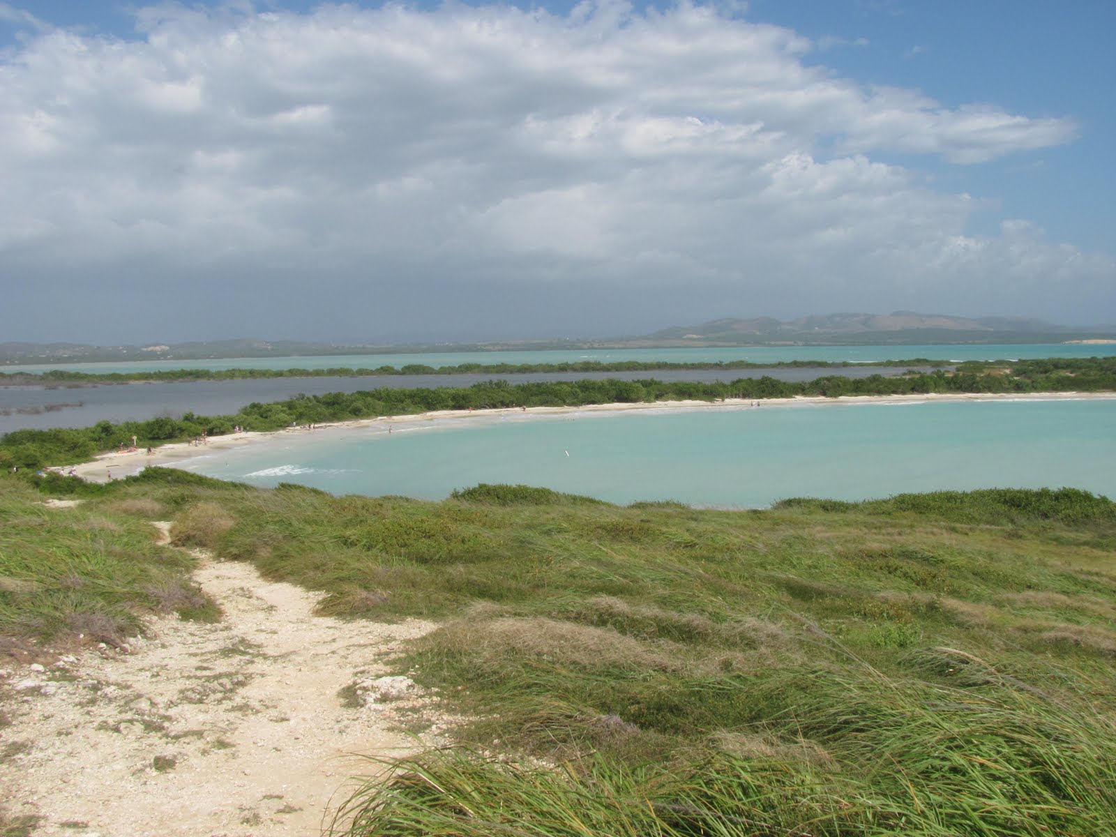
The view from the tower is breath-taking as it gives a full view of the wetlands, mangroves, coastline, and, in the distance, the lighthouse.

We then drove further westward towards the tip, rightfully guarded by a distinctive lighthouse.

The access road to the tip of the island was, by far, the bumpiest road I have ever driven on. Driving on it was probably like driving on the surface of the moon. However, the destination, in the end, was worth the torture.

The Los Morillos lighthouse, also known as Faro Los Morrillos de Cabo Rojo, was constructed in 1882 to guide passing ships through the southeast entrance from the Caribbean Sea through the treacherous Mona Passage into the Atlantic Ocean.

The lighthouse is located on cliffs of limestone, which drop more than 200 feet into the ocean, providing spectacular views.

A gap in the rocky cliffs gives way to a partially hidden bay that features an alluring crescent-moon shaped beach.
Naturally, we trekked down to the beach and had lunch and took many photographs. It was a perfect spot for a relaxed lunch.

Followed by a photo session!

On the way back, we stopped off at Yauco to pick up some groceries. The otherwise nondescript town stands out because of the painted houses. Each house on the hillside in painted a single color but the overall picture is quite a pretty one.

That night was our last at Mary Lee's. We were sad about the stay coming to an end, but excited to see what was in store for us on the north-eastern side of the island.
No comments:
Post a Comment